Monitoring area – Lake Inari and the Pasvik River area
The joint environmental monitoring network covers the catchment area of the Pasvik River. Approximately 70% of the surface area of the catchment is situated in Finland, 5% in Norway and 25% in Russia. Owing to its natural geography and cultural history, the Lake Inari – Pasvik River area marks the point where the north-western corner of the Euro-Siberian taiga meets the barren tundra coast of the Barents Sea. This broad forest and lake region is rich in natural resources even though it is situated so far to the north.
Natural geographical features and fauna
The Inari-Pasvik region is characterized by extensive pine forests, which also contain individual, small groups of the European white birch, downy birch and Siberian spruce. Birch, together with the European alder, aspen and willows, forms true forest only in the coastal zone of the Pasvik River. The ground vegetation typically consists of sparse shrubs and dwarf shrubs and extensive stands of reindeer lichens. There are clear zones in the lush shore vegetation of the Pasvik River.
There are extensive marshes in the low-lying areas along the banks of Pasvik River. The area is an important nesting, resting and migration site for many species of ducks and waders, bean geese and whooper swans. In addition to numerous species of birds, large mammals like Eurasian elks and brown bears live in the whole area. Wolf is an occasional visitor.
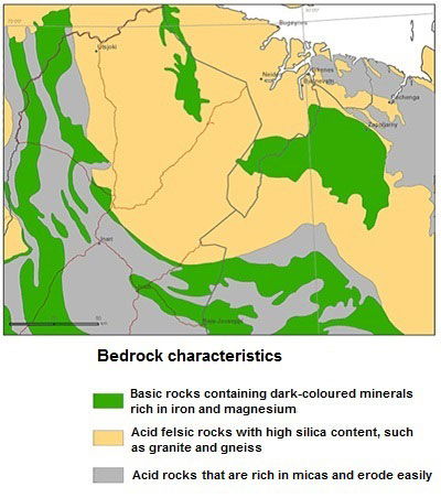
Bedrock and soil
The bedrock of Northern Finland, the eastern part of Norway and the north-western part of Russia consists of over 1900 million-year-old granulite that stretches from the western parts of the Kola Peninsula through Finland and into Norway. A large granite-gneiss complex extends from the Kola Peninsula through the northern Inari and eastern Utsjoki area and continues into Norway. The greenstone zones in each country consist of basaltic and komatitic vulcanites, which include a number of ore deposits. Approximately 400 to 1000 million-year-old sedimentary rocks occur in the northern parts of Norway and Russia.
The dominant mineral soil type in the area is till, the mineralogical composition of which mainly reflects the local bedrock. The size of the material ranges from boulders to clay. The till deposits primarily consist of gravel and sand moraine. The types of moraine formation in the area also include hummocky moraines and drumlins. The average thickness of the till soil in the valleys, on the lower slopes of hills and in flat areas is a few metres. There is no soil at all on the hill and fell tops. Approximately 10% of the surface area is peatland.
Climate
The climate is dry – winters are cold and summers are relatively warm. The annual precipitation is approximately 350-370 mm. The highest recorded temperature in the area is 30.6 °C and the lowest –48.6 °C.
According to the international climate classification, this climatic zone has a short cool summer with a long winter and heavy snow, and there are no dry seasons. Large bodies of water have a considerable heat storage capacity, which means that the lakes and rivers in the region usually freeze late in the autumn (October-November). Ice break-up on the Pasvik River usually occurs in April-May.
Conservation areas
Several nature preserves in the Lake Inari – Pasvik River area are located in the immediate vicinity of each other. The plan is eventually to combine the Vätsäri Wilderness Area (1,555 km²) in Finland, the Pasvik Nature Conservation Area in Russia and Norway (147 km² in Russia and 19 km² in Norway), and the Øvre Pasvik Scenery Protection Area (54 km²) and the Øvre Pasvik National Park (119 km²) into one big “Inari-Pasvik Friendship Park”. The Pasvik Nature Conservation Area has received the status of a Ramsar Area, which means that the area has been recognized as an internationally important wetland area.
Settlement and employment structure
The Inari-Pasvik area encompasses three border municipalities, Pechenga in Russia, Sør-Varanger in Norway and Inari in Finland. Pechenga has the largest population, 44,100 inhabitants in 2010. There were 9,738 inhabitants in Sør-Varanger and 6,789 in Inari in 2010.
Both Pechenga and Sør-Varanger municipalities have grown around mining. Most of the working population in Pechenga is employed by The Pechenganikel combine. The business sector in Sør-Varanger consists primarily of ship repairing, harbour development, agriculture and commerce. A new mining program was initiated in 2007 when the Sydvaranger Gruve AS started production of high-grade iron ore concentrate.
History, the indigenous population, modern settlement and industrialization
The Lake Inari – Pasvik River area has had human occupation for approximately the last 10,000 years. The Stone Age population lived in hunter-gatherer culture. They probably migrated from place to place at different times of the year.
The eastern Sami people (Skolts) were without doubt the original habitants of the Pasvik River area in prehistoric times. The Inari Sami are the indigenous population in the Inari area. The Inari Sami people are also sometimes called the Forest or Fishing Sami, because they originally primarily lived off fishing. Traditionally all of their seasonal settlements were inland in the forest areas, while the Pasvik River Sami moved to the coast to fish during spring and summer.
The Sami community has traditionally consisted of siidas (siida = a hamlet or organized family group which had a common right of use the area). The Inari and Pasvik River siidas both comprised a relatively small number of people who exploited the natural resources over a wide area. Natural borders of siidas followed the watersheds. The internal organization of the siidas was clear and they kept to very strict traditions in dividing the natural resources. The siidas respected each other’s rights and territories.
New people began to move into the area during the 18th century, and the influx of new inhabitants increased in the middle of the 19th century. New cattle farming and more specialized reindeer herding practices were developed and replaced the life style of the indigenous population. Northern Sami people migrated into the area with their reindeer herds.
Life in the region changed considerably at the beginning of the 20th century along with the development of an opencast iron mine in Kirkenes and a nickel-copper smelter in Pechenga.
 The joint environmental monitoring network covers the catchment area of the Pasvik River. Approximately 70% of the surface area of the catchment is situated in Finland, 5% in Norway and 25% in Russia. Owing to its natural geography and cultural history, the Lake Inari – Pasvik River area marks the point where the north-western corner of the Euro-Siberian taiga meets the barren tundra coast of the Barents Sea. This broad forest and lake region is rich in natural resources even though it is situated so far to the north.